Notifications


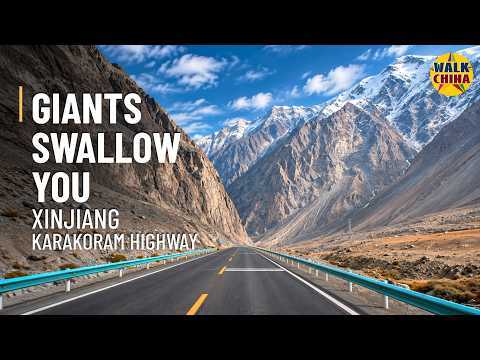
When immense rock walls fill the windscreen and the road shrinks to a thin line, the mountains make everything around them feel small. This drive follows G314 through Xinjiang, China, from the Baisha Mountain–Baisha Lake Scenic Area parking lot to Oytagh Village, passing through Ghez Gorge and the Oytagh red-mountain area. The 71.3 km journey lies in Akto County, Kizilsu Kyrgyz Autonomous Prefecture, along the northeastern Pamir margin. Its power comes from the changing scale of the landscape: towering slopes, deep river corridors and a modern paved road finding its way between them. Each bend offers another perspective on what it feels like to drive surrounded by enormous mountains. 🏔️ From Baisha Lake into Ghez Gorge Baisha Lake and its pale sand-covered mountain form one of the distinctive landscapes of this Pamir route. Beyond the lake district, G314 follows the Ghez River into more deeply cut valleys. Mountain snow and glacier melt feed the river system, while uplift, river erosion and weathering have shaped the exposed slopes. Grey-brown, ochre and reddish rock continually change the view from the car. 🏜️ Oytagh’s red mountains Near the Ghez–Oytagh river confluence, sedimentary formations add vivid layers and textures to the landscape. Sandstone bands, folded strata and erosion gullies reveal the structure of the mountains. Oxidation of iron-bearing minerals contributes to their red-brown appearance. 🛣️ Engineering between river and mountain G314 forms part of the Chinese section of the Karakoram Highway, also known as the China–Pakistan Friendship Highway. It serves local communities, regional transport and tourism. Bridges cross the river corridor, while the approximately 2.6 km Kongur Tunnel improves passage through the Laohuzui area. The drive offers a road-level view of engineering adapted to steep, complex terrain. 🏺 Older routes and everyday life Travel through this valley predates the asphalt. The Ghez caravan-station remains recall historic Congling routes associated with the Silk Road. Around Oytagh, agricultural and pastoral life continues alongside access to red mountains, forests and glacier destinations. Cloud and blowing dust affected visibility and distant colours on the filming day. This video preserves that actual driving atmosphere, with no narration or music—only authentic vehicle and ambient sounds. 📍 Route Information 🌏 Location: Akto County, Kizilsu Kyrgyz Autonomous Prefecture, Xinjiang, China 🛣️ Road: G314 · Karakoram Highway / China–Pakistan Friendship Highway 🚩 Start: Baisha Mountain–Baisha Lake Scenic Area parking lot 🏁 Finish: Oytagh Village 📌 Along the way: Ghez Gorge, Kongur Tunnel and the Oytagh red-mountain area 📏 Distance: 71.3 km ⏱️ Driving time: 1 hour 7 minutes 📅 Filmed: November 2 ⛰️ Recorded elevation range: 1,734–3,338 m 🌥️ Weather: Partly cloudy with blowing dust 🎥 Quality: High-quality 4K footage 🎧 Audio: No narration, no music; real driving and ambient sounds Watch on a large screen to appreciate the scale. Does this landscape make you feel wonder, awe or a little overwhelmed? Share your thoughts and subscribe for more roads across China. #Xinjiang #KarakoramHighway #4KDrive #China #ScenicDrive #Pamir
Изглежда въведохте грешна парола click here за да въведете паролата отново.
Този уебсайт използва бисквитки, за да ви предостави по-добра услуга. Съгласни ли сте с това?
Уебдизайн и изработка: NapraviMI.Website